Neighborhood Planning: Five Points/Northeast Huntsville
In Five Points and Northeast Huntsville, all signs point to a rapidly transforming section of the City. Excellent access and proximity to employment (Downtown and Huntsville Hospital) and recreation (Monte Sano and the Land Trust) make it an attractive place for people of all ages. As development pressures mount, now is the time to discuss the future of this area.
(Photo credit: Bic Green)
Date: February 28, 2018
Presenters: Dennis Madsen and James Vandiver, City of Huntsville
Location: Cooper House, Central Presbyterian Church (405 Randolph Ave. SE)
The BIG Picture held its second Five Points/Northeast Huntsville Small Area Plan meeting on February 28, 2018. Around 60 residents and interested citizens turned out on a (very) rainy evening. Following a brief presentation of the first meeting’s results, attendees participated in four interactive exercises:
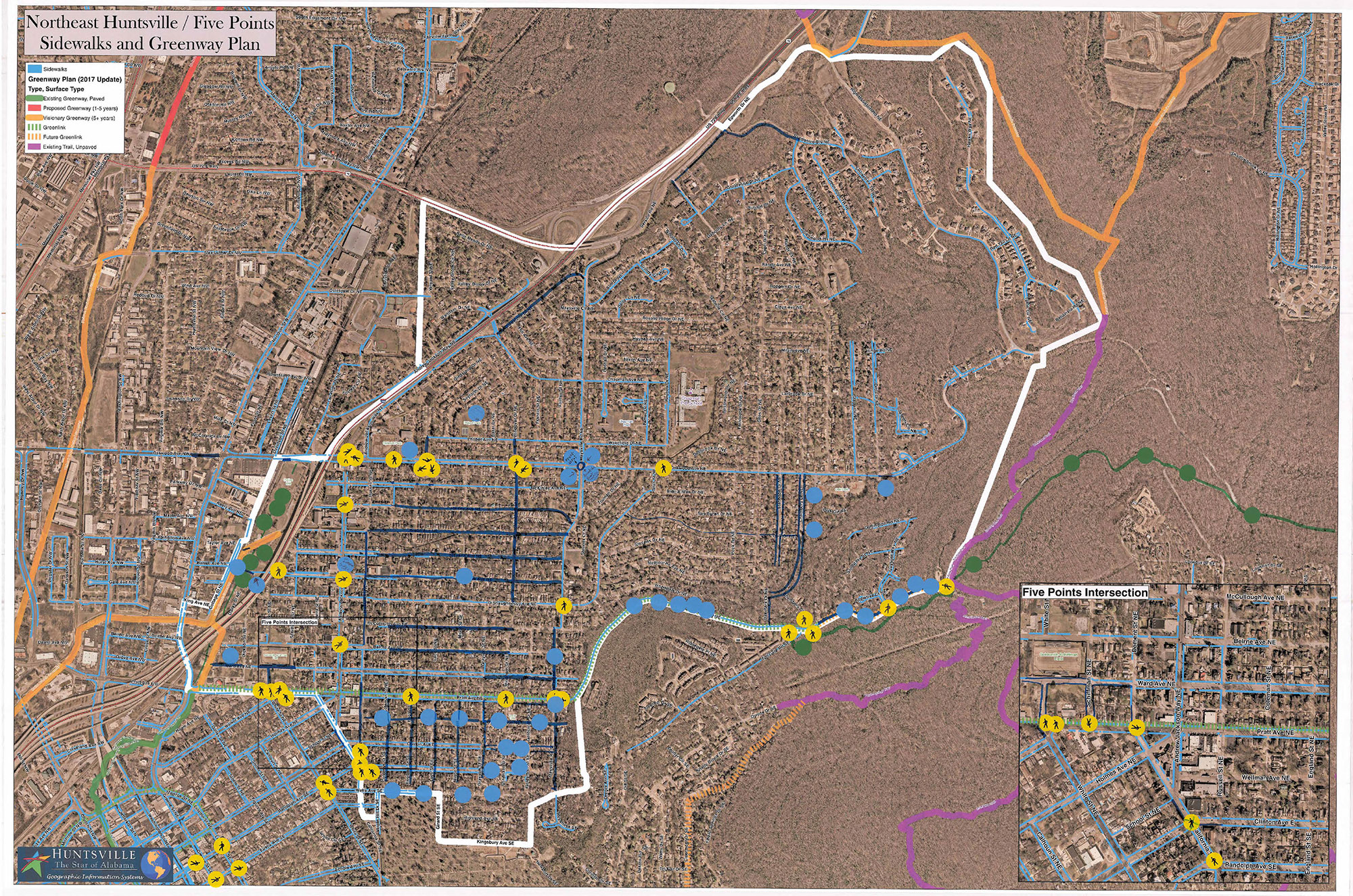
Pedestrian Connectivity
Where are sidewalks/crosswalks needed?
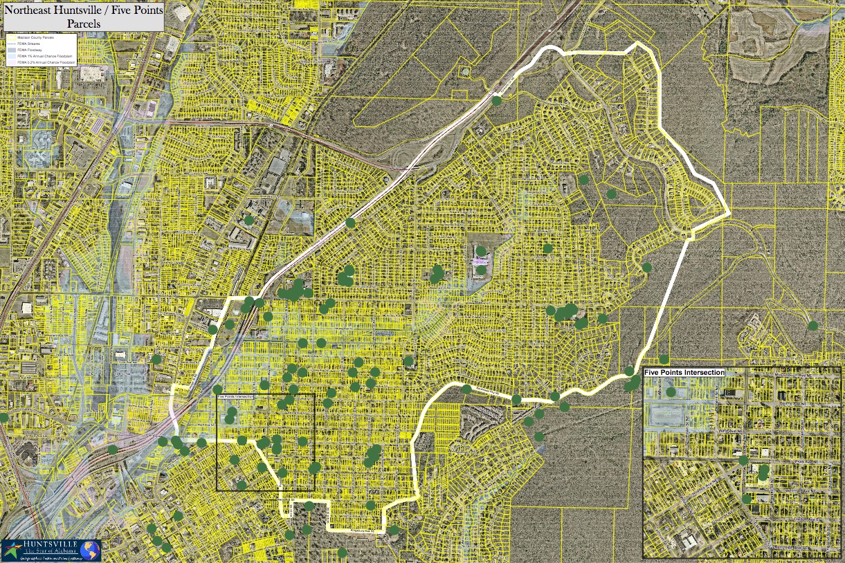
Participants drew potential sidewalk and greenway connections, and indicated crosswalk locations on busy streets. Blue lines indicate new sidewalks (blue stickers in support); green lines are new greenways (green stickers in support); yellow “ped” stickers are new crosswalks:
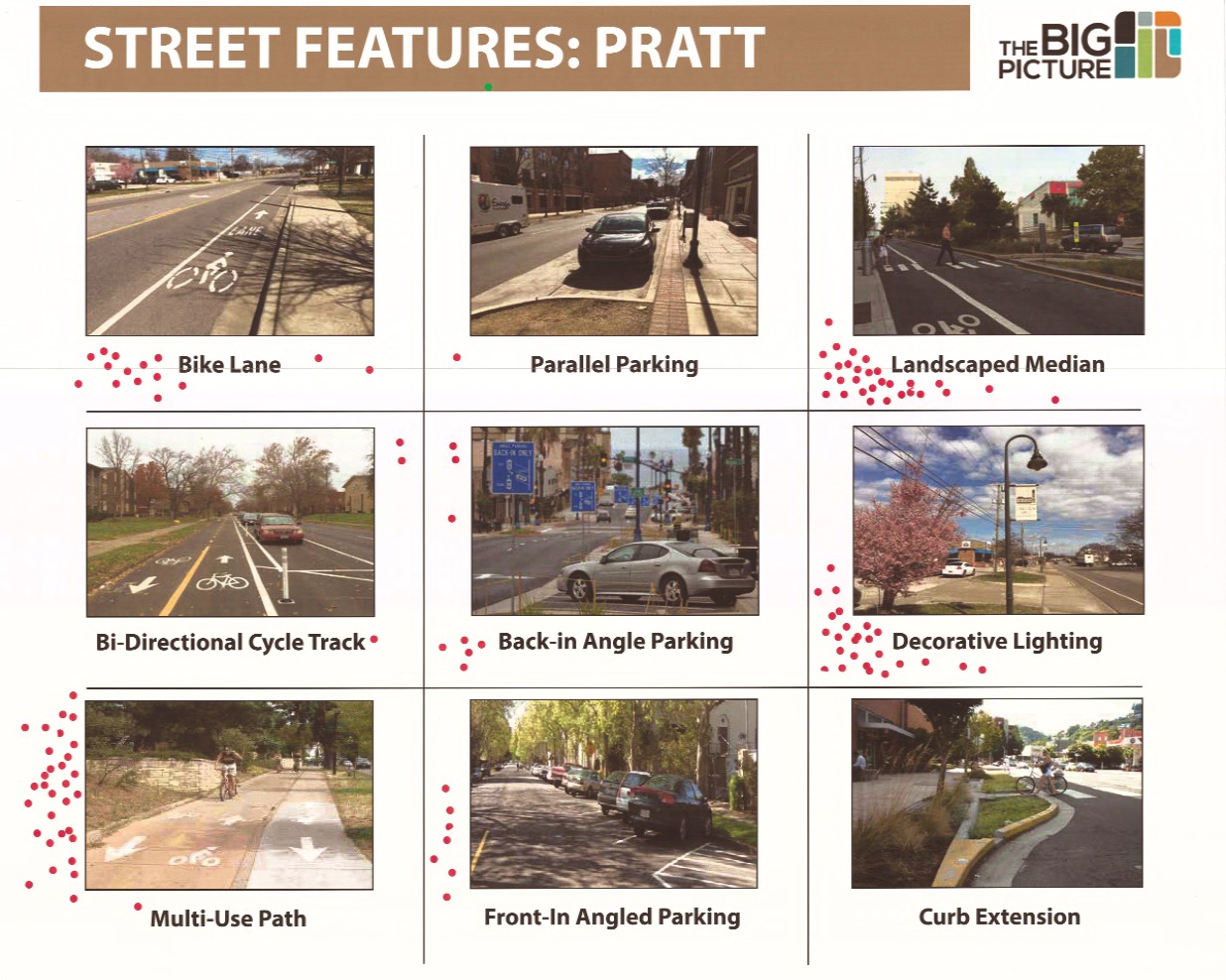
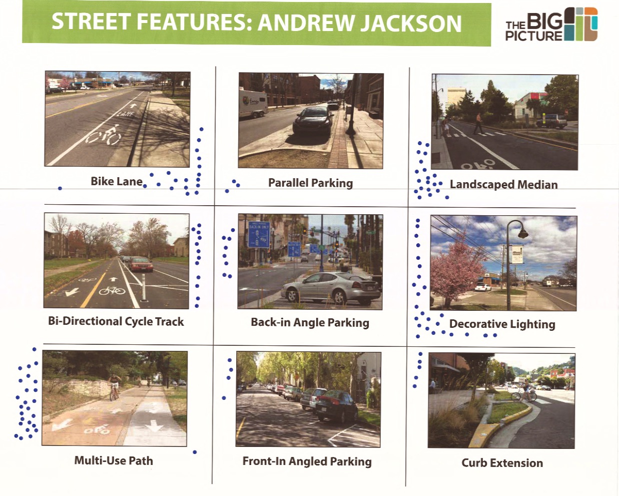
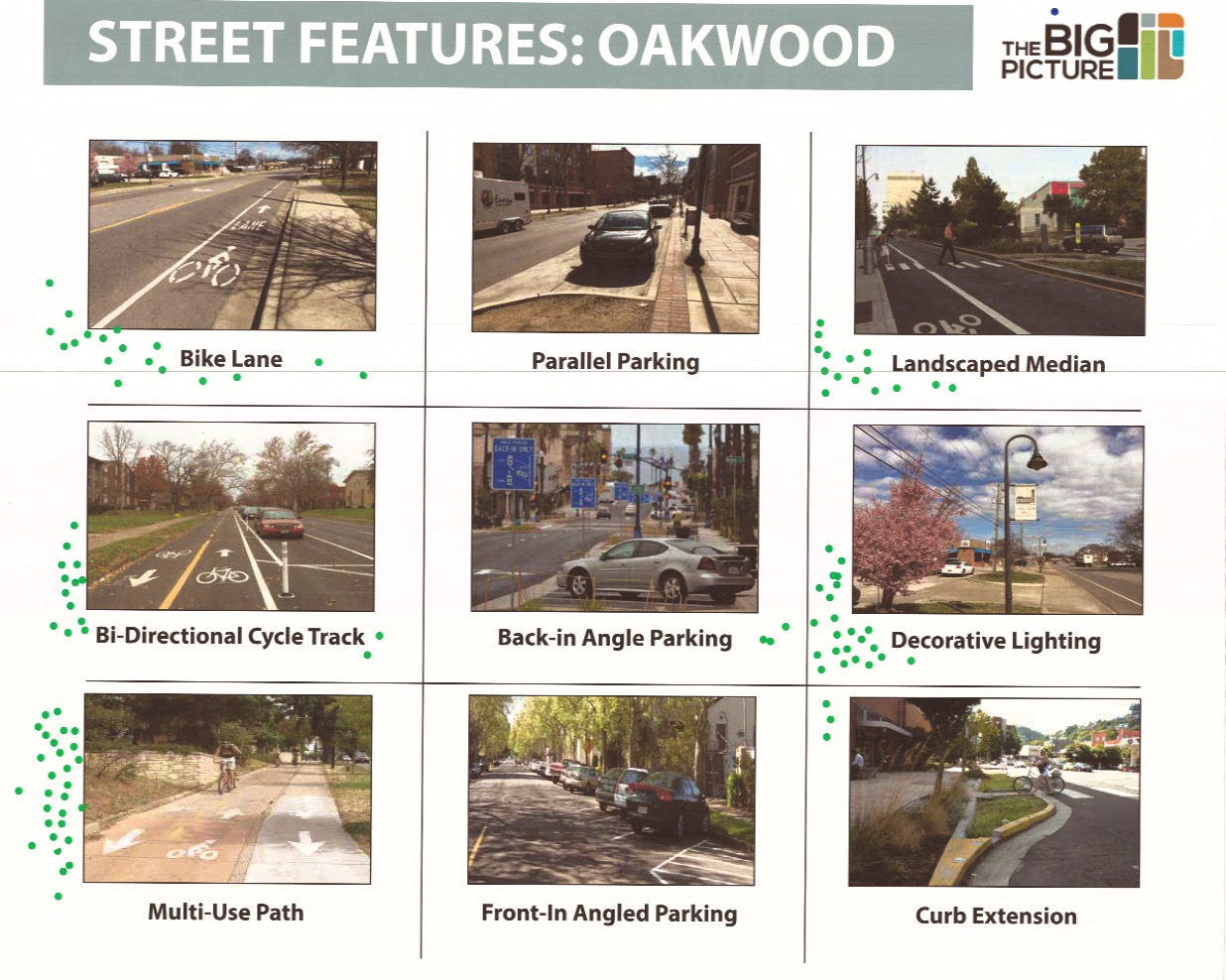
Streetscapes
How can the study area’s “gateway streets” (Andrew Jackson, Oakwood, Pratt) be designed to better reflect/connect the surrounding neighborhoods? How can these streets better accommodate all modes of transportation?
Participants chose three street features they would like to see on three corridors– Andrew Jackson between Ward and McKinley; Oakwood between Andrew Jackson and Maysville; and Pratt between the Chevron station and Dement. While other street segments in the study area are candidates for new cross-sections, these three have the potential for the most visible and drastic improvements, including lane reduction (from 4-5 lanes to 3). On each segment, multi-use paths, decorative street lighting, landscaped medians, and bike lanes were the most requested improvements. (Dots indicate individual “likes” for each street feature.)
Pratt
Land Use
What types of commercial/residential development are requested/desired by the community?
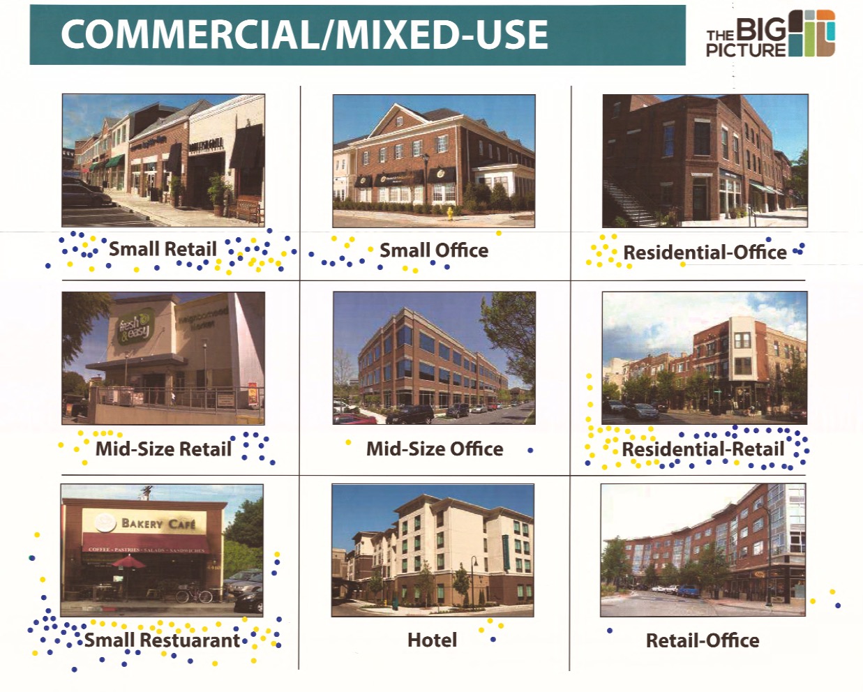
Commercial/Mixed-Use
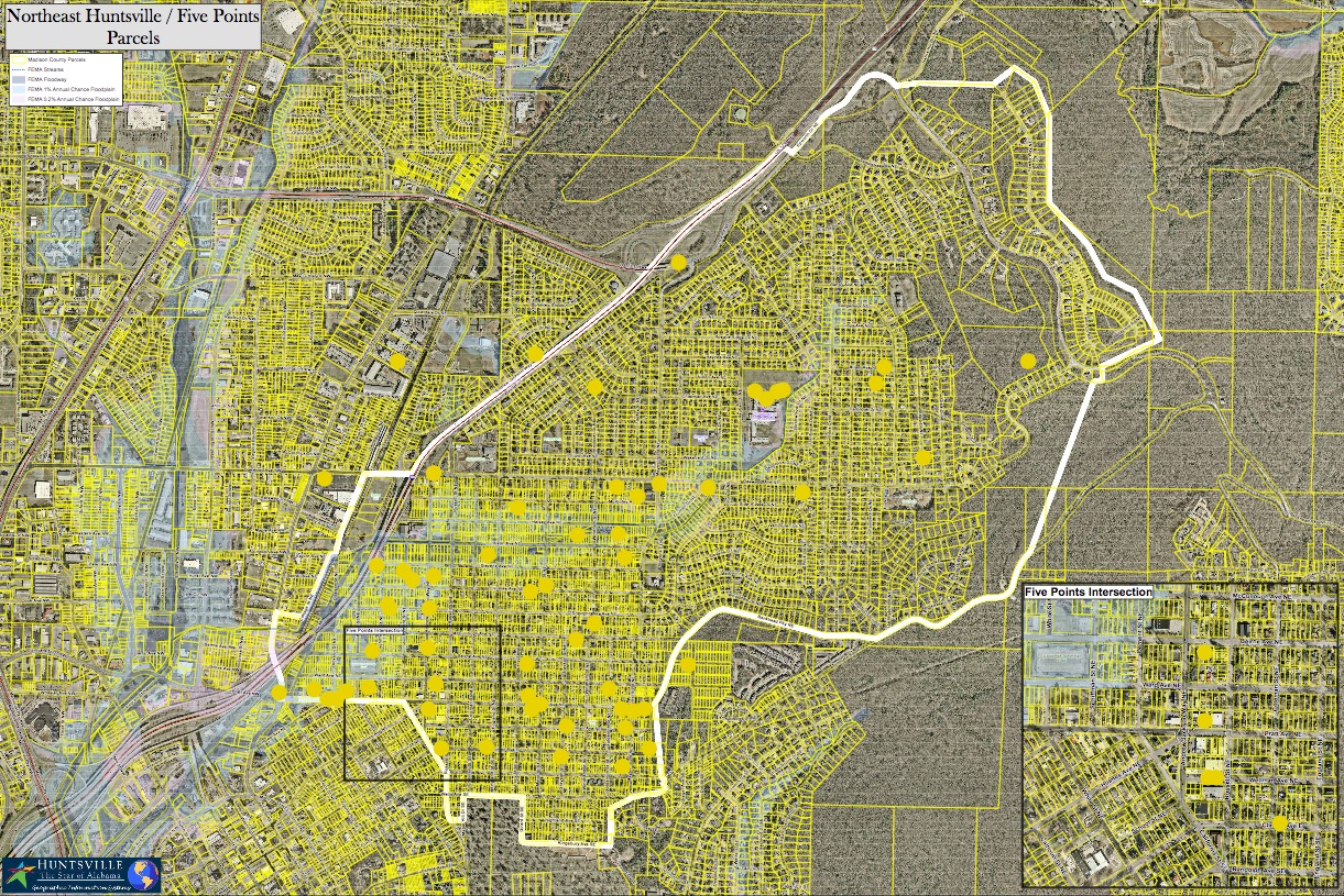
 In this part of the exercise, participants were asked to select three general types of commercial development that are desired within two of the study area’s corridors– Andrew Jackson/Dallas Mill (yellow dots); and Pratt/Five Points (blue dots).
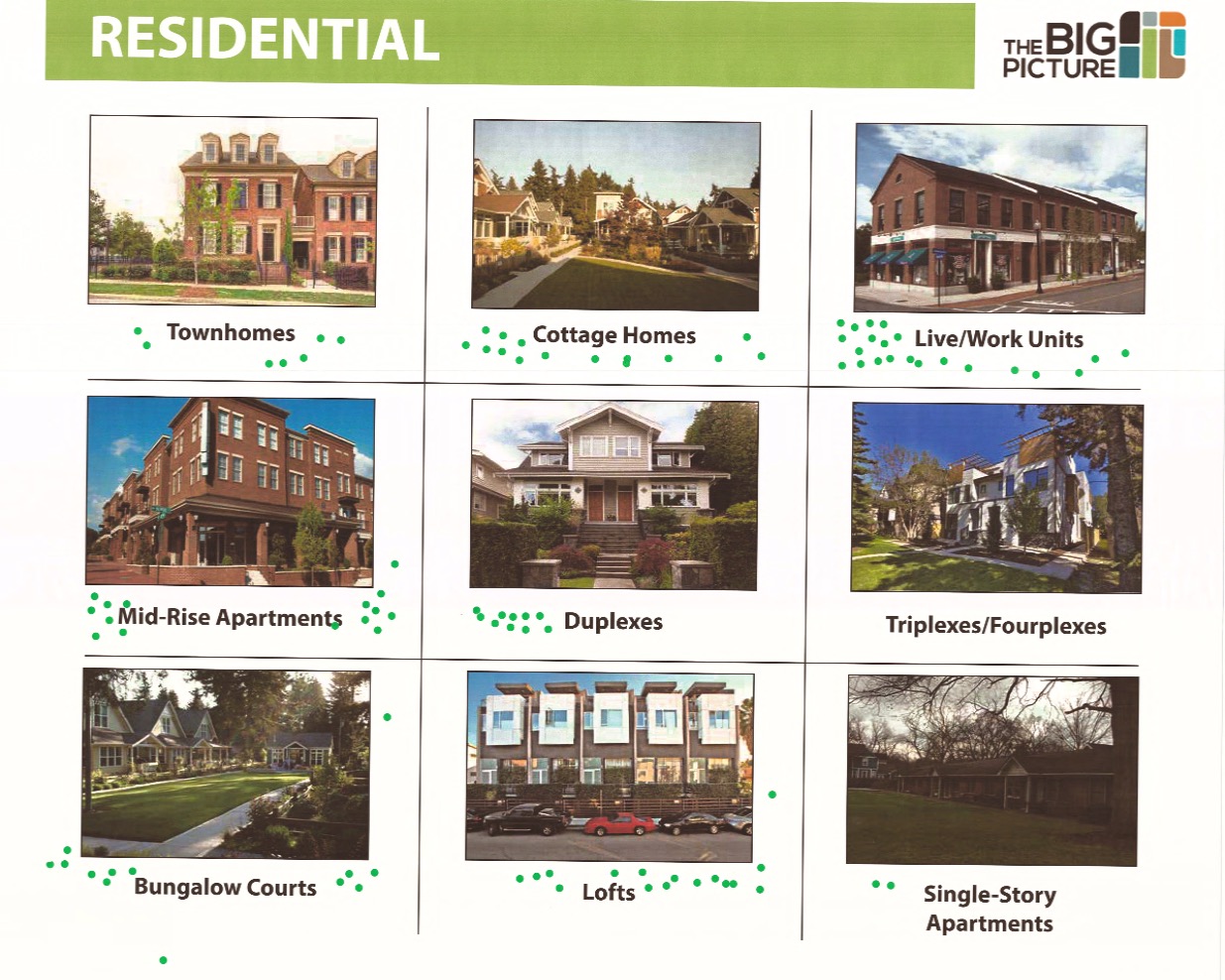
Residential
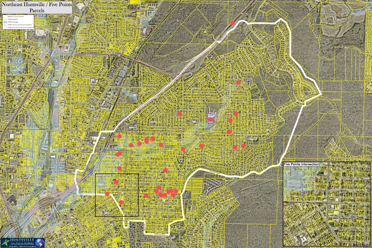
In the initial kick-off meeting, residents expressed a desire to keep a mix of housing types within the study area. This board shows different styles of housing other than single-family detached, the dominant housing type. Some of the housing styles on the board exist in the neighborhood, while others would be new to the area. Participants were asked to pick three housing styles (green dots) they would like to see more of in the study area.
Anything Else?
A catch-all exercise for topics that weren’t covered.
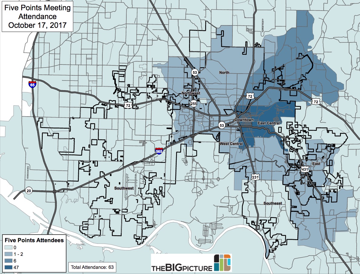
Date: October 17, 2017
Presenters: Dennis Madsen and James Vandiver, City of Huntsville
Location: Cooper House, Central Presbyterian Church (405 Randolph Ave. SE)
The BIG Picture held its Five Points-Northeast Huntsville Small Area Plan kickoff meeting on October 17, 2017 at the Cooper House. Around 75 residents and interested citizens turned out for the presentation and map exercise. The meeting began with a recap of our initial assessment of the study area, covering demographics, real estate, building data, etc. Following the presentation, the audience broke into ten groups for a “SWOT” exercise. Using stickers and labels on a large map, attendees were asked to identify the Strengths, Weaknesses, Opportunities and Threats (SWOT) within the study area. The top results of this exercise are summarized below.
Special thanks to everyone who came out; the Planning volunteers; the Five Points Historic District Association; the Northeast Huntsville Civic Association; and Central Presbyterian Church for the use of their facility.
Strengths
Parks
Nearly every group expressed support for the variety of parks within the study area.
Land Trust
Attendees liked the easy access to multiple nearby Land Trust trailheads.
Five Points commercial core
Participants appreciated the variety of businesses within the commercial core, as well as the appearance of the section around Star Market-1892 East.
Access to Downtown
There is easy access (via car, bike, or foot) to the growing activity in Downtown. Interest was expressed in expanding access, especially for bikes (bike share expansion, greenways, bike lanes).
Accessibility
There is easy (car) access to points outside the study area, including multiple exits to 565. The easy to navigate street grid was also mentioned as a positive.
Housing Diversity
There is a variety of housing in the study area—not only housing types, but housing ages. The housing options available in the study area allow for a wide range of income and age ranges to live in the area, further preventing disinvestment.
Walkability/sidewalks
Residents enjoy the relative walkability of the study area, and sidewalks (where available). Top attractions are parks and commercial areas.
Schools
Attendees liked the close proximity of the public schools that serve the study area. Neighborhood schools are seen as a positive amenity.
Restaurants
There are a variety of restaurants in the study area, including 1892 East and Thai Garden.
Honorable mention: Tree cover; transportation options (e.g. transit access); alleyways; local businesses
Weaknesses
Commercial corridors
The appearance of some of the study area’s main corridors could be improved, especially Pratt and Andrew Jackson.
Chapman/Lee schools
The perceived quality of these schools weigh down on the surrounding neighborhoods.
Lack of sidewalks/bad sidewalks
The lack of sidewalks in parts of the study area is troubling, as well as the poor state of repair of some of the existing sidewalks.
Wellman
Several groups identified the Wellman Avenue commercial block as an area in need of improvement (e.g. streetscape)
I-565
The viaduct over the Dallas Mill neighborhood is an eyesore for nearby residents. Several groups discussed using the space underneath the bridge for a public use, such as a park or community market.
Flood plain
Concern over the wide swath of designated flood plain that bisects the study area. This hinders development and property improvements within the zone.
Honorable mention: Tree trimming by utilities; on-street parking; alleyway maintenance
Opportunities

Dallas Mill
The former Dallas Mill site is an opportunity in more ways than one. Part of the land will be used as a major component of the Dallas Branch Flood Mitigation project. The remainder of the site could be redeveloped.
Commercial corridors
Opportunities for redevelopment and streetscape improvements along the main corridors of the study area. Andrew Jackson and Pratt were identified most often, as well as the commercial block of Wellman (between Andrew Jackson and Russell).
Greenways
Expressed interest in new greenways connecting the study area to areas further afield, especially Downtown.
Maysville/Stevens Drive
Several groups discussed the creation of a community “gathering space” at the corner of Maysville Rd. and Stevens Dr. near the Oak Place mansion.
Maysville/Oakwood Avenue
Create a neighborhood business node at the intersection of Maysville and Oakwood; potential for a small grocery store?
Rezoning commercial areas
Rezone the study area’s commercial zones to the new C6 zoning, where applicable.
Honorable mention: Oak Park utilization; Missing Middle Housing
Threats
Safety/Crime
Safety and crime issues were the number one threat facing the study area, according to participants.
Flood plain
The flood plain hinders development in a large portion of the study area.
Code enforcement
Several groups expressed a desire for increased code enforcement in their neighborhoods.
New development
Some of the new residential development occurring in the study area was considered a threat by several groups.
Honorable Mention: Trailer park (on Windham); the loss of affordable housing
Map Exercises
Group 1 | Group 2 | Group 3 | Group 4 | Group 5 | Group 6 | Group 7 | Group 8 | Group 9 | Group 10
Attendance Map
Last modified: October 31st, 2018 at 9:38 pm