Transportation
Huntsville is well-known for its reasonable commute times; indeed, the average commute data is often a selling point when recruiting industry for the metro area. Bisected by two major thoroughfares – I-565 and Memorial Parkway – it is very easy to get around town, and do so quickly, even during “rush” periods. In order to maintain a relatively smooth commute, the City (in partnership with the State) is planning to invest more than a quarter of a billion dollars over the next half decade to further improve and expand the capacity of the existing network.
Take a look at the 2019 Alternative Modes Review.
Average Commute Time by City, 2015
Huntsville has a lower average commute time than many of the cities it competes with for jobs and people.
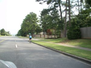
A cyclist on Bailey Cove Road in Southeast Huntsville.
However, like many cities that experienced heavy growth during the latter half of the 20th century, the vast majority of the transportation infrastructure supports the automobile, to the exclusion – and often the detriment – of other modes. Bicycle facilities are sparse, and safe cycling, be it for commute or recreation, can be a challenge. The sidewalk network is fractured and inconsistent, and even where sidewalks exist, in many cases they are not in a particularly well-designed pedestrian environment.
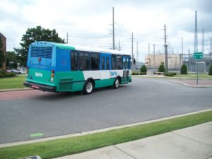
A Shuttle bus in Downtown Huntsville.
The primary transit option is the Huntsville Shuttle service, which offers relatively thorough coverage of the core and surrounding neighborhoods. The main challenges are the limited headways (most routes circulating hourly) and sparse evening/weekend service. The lack of more extensive transit service has less to do with municipal policy than it does with the development patterns. There are few nodes within the city that are of a transit-supportive density that would make higher capacities or more frequent runs financially feasible. Put simply, we’ve discussed the “sprawl” of Huntsville before, and its effects are most apparent here in transportation.
In short, the current network is heavily-oriented toward automotive traffic, and that is unlikely to change in the near term. However, with dwindling state and federal funds, the city may not be able to build enough roads to satisfy anticipated population growth. City and metro leaders will need to be creative in order to maintain the commute to which we have become accustomed. Otherwise, the community as a whole may feel the anxiety of true traffic congestion.
Mode of Transportation to Work in the City of Huntsville, 2014
Source: U.S. Census Bureau

The Huntsville MPO logo.
Regional transportation planning is administered by the Huntsville Area Transportation Study, more commonly known as the Metropolitan Planning Organization (MPO). MPOs are required by the Federal Highway Authority (FHWA) for urban areas of 50,000 or more and designated by the Governor. The members of the Huntsville-Area MPO are Huntsville, Madison, Owens Cross Roads, Triana, Madison County, and the Top of Alabama Regional Council of Governments (TARCOG). Members are represented on the MPO board by a member of their government. Even though the BIG Picture is a City of Huntsville process, we recognize that transportation is a regional issue. To maintain the high-functioning transportation network, the city will (through the MPO) need to coordinate with other government entities in the region.
The Alabama Department of Transportation (ALDOT) groups roadways into “functional classifications” depending on the street design and traffic counts. Traffic counts are conducted annually by the City of Huntsville and ALDOT. The seven classifications used in the Huntsville area are shown in the map. View the Functional Classification Map for the Huntsville MPO study area.
Congestion/Level of Service
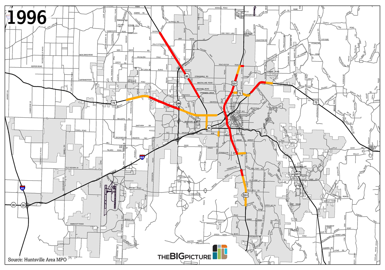
Transportation planners use Level of Service (LOS) calculations to determine existing and future congestion on major roadways. Similar to school grades, LOS scores are scaled from A to F, with F being the most congested. A road segment is considered “acceptable” if the LOS score is higher than level D. The maps below show unacceptable Levels of Service (levels E and F) on roads in and around Huntsville in 1996 and 2012. For comparison, a 2035 scenario is shown where no further investments are made to the network.
The goal of the Public Transportation Division is to provide adequate and efficient community transportation services for the general public, senior citizens, physically challenged citizens, commuters, and individuals with limited transportation alternatives.
Transit service in Huntsville is operated by the City of Huntsville’s Department of Parking and Public Transit. Fixed-route service is branded as the Huntsville Shuttle. The Shuttle has nine routes that run Monday-Friday from 6am to 7pm, and two special weekend evening routes service UAH and Downtown.
Fixed-route transit (Shuttle) map
Type your address in the bar below to see if there’s a transit route near you.
Paratransit service is also available, branded as Handi-Ride. Outside of Huntsville city limits, on-demand paratransit service is available in Madison and unincorporated Madison County. Alabama A&M and Oakwood Universities both operate campus bus systems.
Huntsville Shuttle/Handi-Ride Annual Ridership, 2009-13
The only intercity bus service available is via Greyhound. Six buses depart Huntsville daily—three northbound to Nashville, three southbound to Birmingham.
Huntsville International Airport (HSV) is located thirteen miles west of Downtown and one mile south of Interstate 565. HSV is governed by the Huntsville-Madison County Airport Authority (HMCAA). The authority oversees the operation, maintenance, and development of more than 7,000 acres– including the passenger terminal, the International Intermodal Center for cargo, and Jetplex Industrial Park. In 2015, approximately 1.1 million passengers traveled through HSV.
Cargo transport is very important to the airport’s operation. HSV is one of the top 50 largest airports in the US by cargo movements (Source: Airports Council International). More than 85,000 metric tons of cargo was loaded and unloaded at HSV in 2013.
The Huntsville Executive Airport, a general aviation facility, is located north of Huntsville city limits in Meridianville, AL. It is a private airport governed by the Madison County Executive Airport Authority.
[table id=2 /]
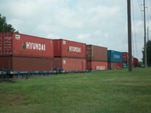
A freight train nearing the International Intermodal Center in Southwest Huntsville.
Huntsville has three active rail lines- a well-used East-West trunk line and Jetplex spur owned by Norfolk Southern (NS), a sparsely-used North-South line owned by the Huntsville-Madison County Railroad Authority (HMCRA), and a weekend tourist line run by the North Alabama Railroad Museum in Chase.
The HMCRA still owns most of the right-of-way for an abandoned rail line north of Downtown towards Alabama A&M University. Another abandoned spur is located near the 565/255 interchange and runs into the Redstone Gateway development. It is in the process of being converted into a greenway.
Huntsville does not currently have passenger rail service. The last train picked up passengers in Huntsville in 1968. Amtrak service to Huntsville was discussed in the early 1990s as an extension of the Gulf Breeze route, but that route was discontinued in 1995.
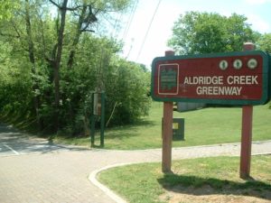
An entrance to Aldridge Creek Greenway in Southeast Huntsville.
The City of Huntsville began implementation of a Greenways Plan in 1992. The multi-use paths are very popular city-wide. Greenways not only provide a scenic, car-free refuge–they also promote recreation and fitness. Greenways allow the City to make public use of sewer and floodway rights-of-way.
One common complaint of the greenways system is that it’s not connected, and in many cases, one has to drive to the greenway.
Mountain bike trails are available at Monte Sano State Park as well as the Wade Mountain Preserve. The Ditto Landing Master Plan includes mountain bike trails.
Greenways and trails also promote physical fitness and health. A 2004 study, using bike/pedestrian trails in Lincoln, Nebraska to reduce health care cost associated with inactivity, concluded that for every $1.00 spent on trails, almost $3.00 of public health was produced. (Source: Journal: Health Promotion Practice; April 2005 Vol. 6, No. 2, 174-179, “Cost-Benefit Analysis of Physical Activity Using Bike/Pedestrian Trails” by Guijing Wang, PhD, et al.)
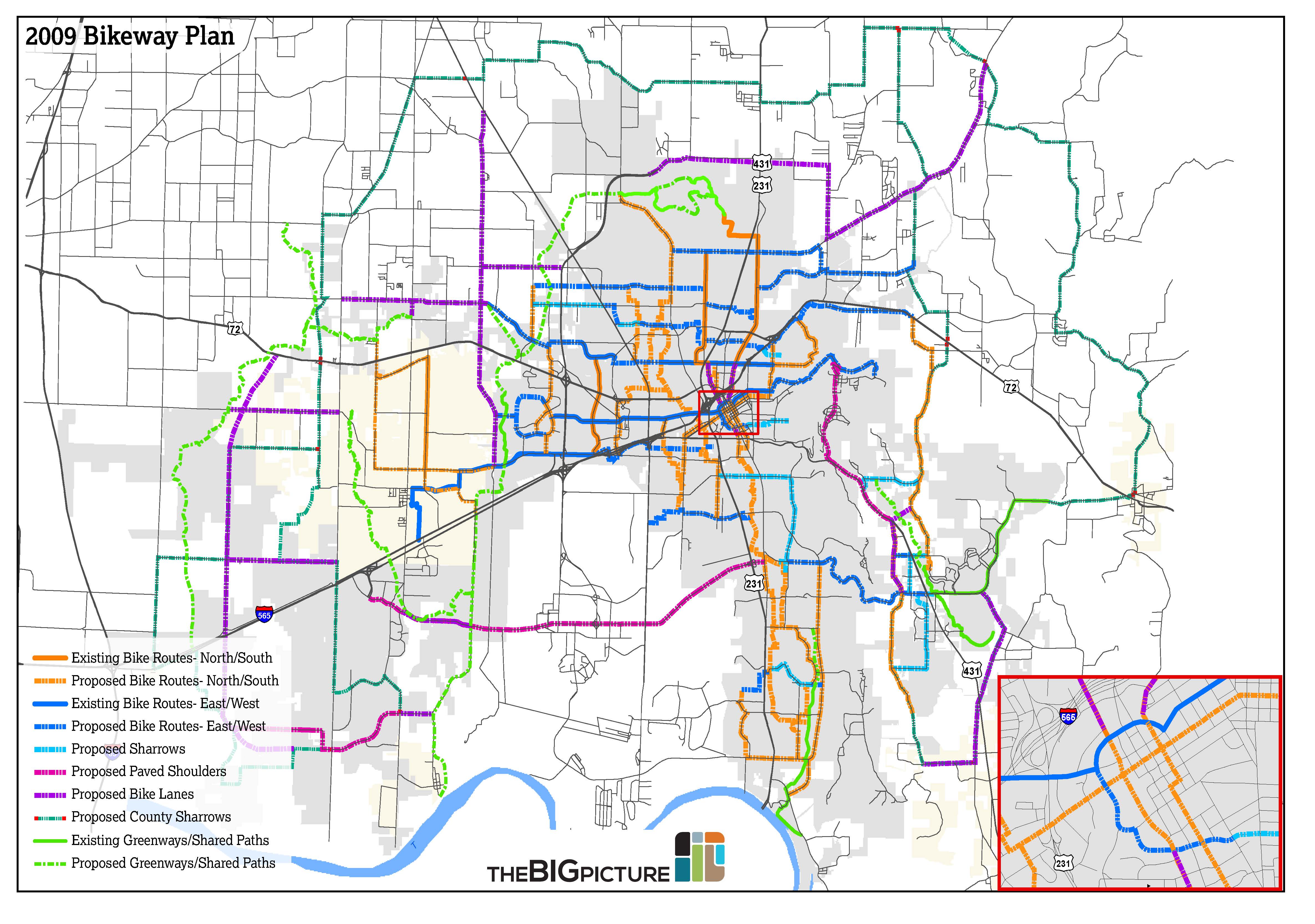
Huntsville Greenways Plan
The last update of the Huntsville Greenways Plan was approved in 2006. Nearly 30 miles of greenway have been built in Huntsville, with approximately 150 miles proposed or under construction.
The construction of bike lanes is a fairly recent development in Huntsville. The most recent federal regulations require MPOs to include bicycle lanes and pedestrian options on all new road construction unless extenuating circumstances prevent the MPO from doing so. Major City road projects since 2008—such as the widenings of Oakwood Road and Meridian Street– have included bike facilities. There is a growing demand for bike lanes in the city.
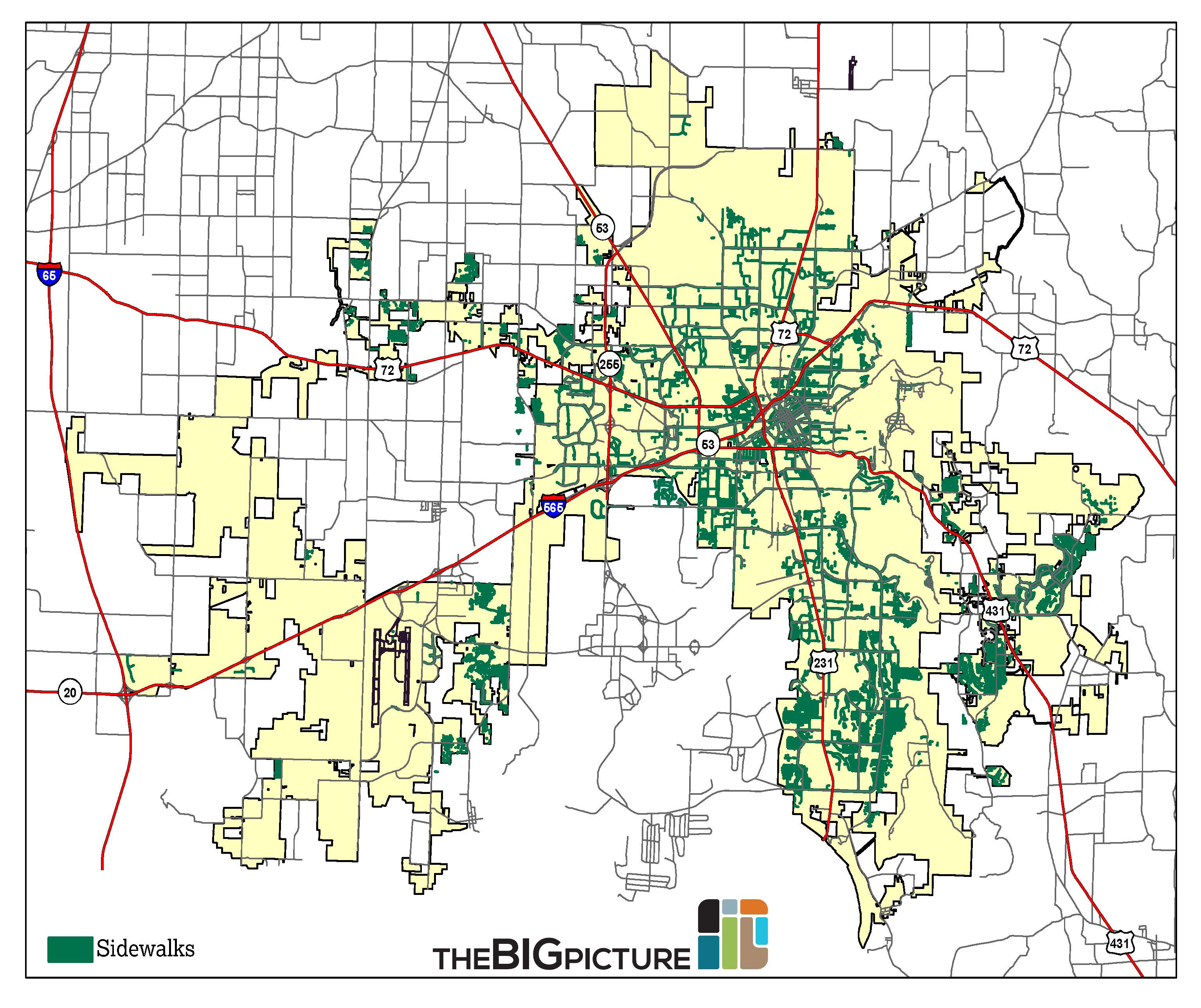
Sidewalks
Most major streets in Huntsville have sidewalks. However, many are narrow and filled with obstructions, such as utility poles and tree roots. In many areas, they don’t serve pedestrian functions due to a lack of adequate lighting, signage, and proximity to high-speed traffic.
In general, sidewalks were not built in neighborhoods that were built out between the 1950s and 1970s. Residential areas built before and after generally have good coverage of sidewalks.
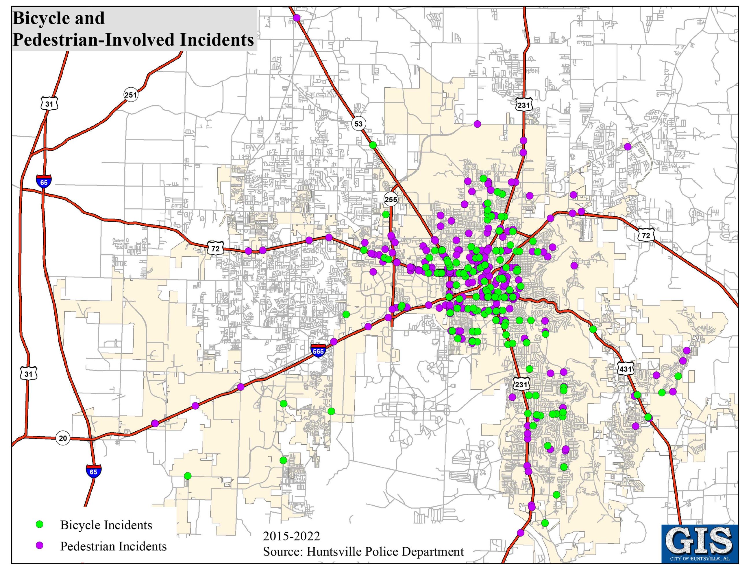
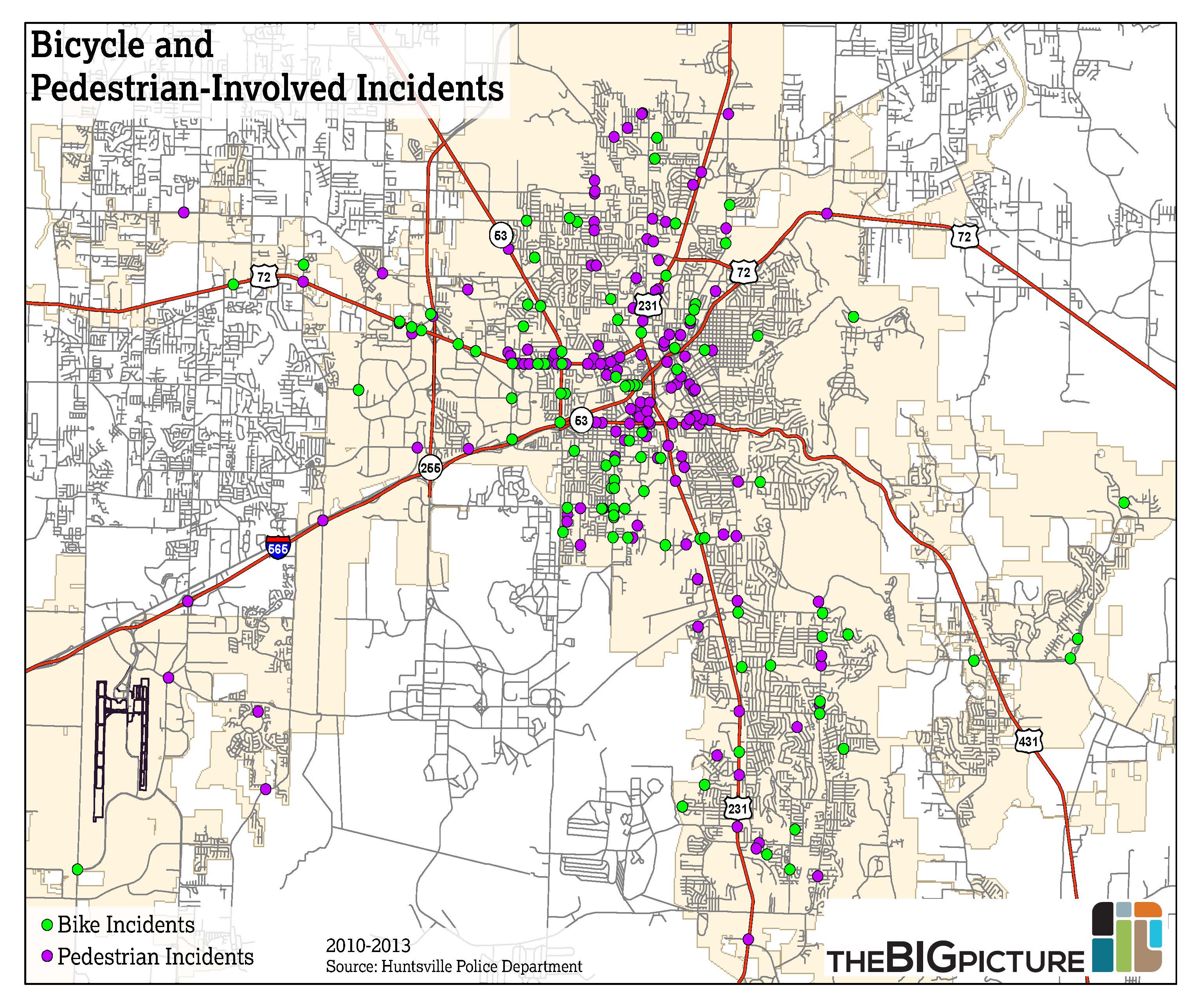
Between 2010 and November 24, 2013, there were 98 bike-related incidents (only 97 are mapped– one had an invalid location). Areas with a high occurrence of bike incidents include Triana Blvd., University Dr., Holmes Ave. and Meridian St.
Between 2010 and November 24, 2013, there were 190 pedestrian-related incidents (only 156 are mapped– the rest had invalid locations). Areas with a high occurrence of pedestrian incidents include University Drive near the Northwoods housing project, Downtown, the area surrounding the Butler Terrace housing project, and the Medical District.
Bicycle and Pedestrian-Involved Incidents: 2015-2022
Bicycle and Pedestrian-Involved Incidents: 2010-2013
The Long-Range Transportation Plan (LRTP), maintained by the Huntsville MPO, maps out the next 25 years in transportation projects throughout the MPO study area. The LRTP is updated in full every five years, with amendments as needed. The last full update, the 2040 Plan, was enacted in March 2015.
The LRTP separates projects into two categories: financially constrained and visionary. Financially constrained projects can be built using available funds. Examples of financially constrained projects within Huntsville city limits include:
- Interchange: Memorial Parkway at Mastin Lake
- Widening: US 72 West, Providence Main to County Line
- Interchange: Memorial Parkway at Martin, Byrd Spring, and Lily Flagg
- Widening: Cecil Ashburn, Carl T. Jones to Old Big Cove
Visionary projects are not currently funded, but are added for planning purposes. Examples of visionary projects within Huntsville city limits include:
- Interchange: Memorial Parkway at Winchester
- Interchanges: US 72 at Moores Mill and Shields
- Arsenal East Connector: I-565 to Memorial Parkway/Hobbs Island Rd.
- Widening: Research Park Blvd. from I-565 to University Dr.
Capital Improvement Plan
The City of Huntsville created a 10-year Capital Improvement Plan (CIP) in 1990 to “help allocate resources over time” for the construction and maintenance of public infrastructure, as well as incentivize and support City growth and development. (City of Huntsville, FY 2015 Budget) In 2014, the City passed an additional 1-cent sales tax for transportation and economic development. The plan also includes funds for resurfacing, sidewalks, traffic calming, and greenways. Major transportation projects that are planned or under construction in the 2014 CIP include:
- Greenbrier Parkway: I-565 to Huntsville-Browns Ferry Rd.
- Downtown Gateway: Governors to Lowe
- Northern Bypass: Pulaski to Parkway
- Bridge Replacement: Hobbs Island Rd.
Planned Projects, 2015-2020 (City of Huntsville Investment)
*The Transportation Improvement Plan budget includes Restore Our Roads funding.
The BIG Picture will begin a Mobility Plan in the next few years that will look into all modes of transportation.
Paratransit will become more important as the population ages. When funding is made a priority, fixed-route transit ridership will continue to increase as more routes are added and headways (time between buses) decrease.
The Airport Authority approved their last Master Plan in 2010. Plans include expansion of the passenger terminal, parking garage, and hangar facilities. A visionary goal of the Airport is to become an airline hub and the Airport has set aside land in Limestone County for a new passenger terminal if those plans come to fruition.
Former railroad rights-of-way should be reserved for future greenways and potentially high-capacity transit.
With the revitalization of high-speed rail plans in the United States, Huntsville may explore passenger connections to neighboring cities such as Birmingham, Chattanooga, and Atlanta.
The City should make connecting the greenway pieces a priority, and create more access points for bicycles and pedestrians.
Last modified: August 25th, 2022 at 6:47 pm