Natural and Historic Resources
The Tennessee Valley is blessed with incredible and diverse natural beauty. The river and its tributaries offer stunning vistas and a wide array of recreational opportunities. The tree-covered mountains are visible from almost anywhere in the city of Huntsville, and create an incredible backdrop for daily life in the metro area. The biological diversity in North Alabama has helped create a rich local culture around wildlife, and it draws visitors to the city all throughout the year. Our unique history as an agrarian town-turned-techno city attracts history buffs of all kinds, from watercress to the Civil War to outer space and beyond.
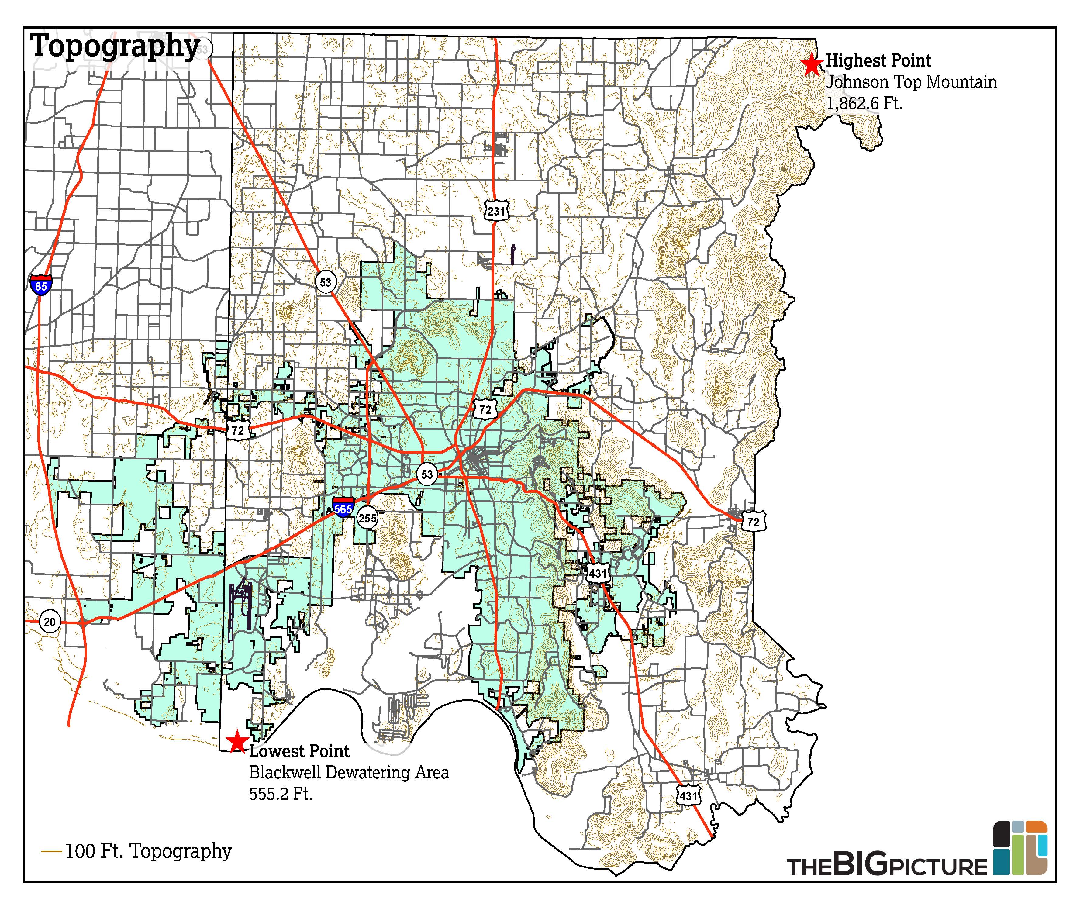
Huntsville and Madison County have a diverse range of terrain, from the wetlands near the Tennessee River to the edge of the Cumberland Plateau. The change in elevation in Madison County from the lowest point to the highest is just over 1,300 feet.
At 1,652 feet above sea level, the highest point in Huntsville city limits is at a water tower in Monte Sano State Park. The lowest elevation in city limits is found at the Tennessee River, which has an elevation of 556 feet above sea level.
Topography affects the development pattern of an area. In recent decades, Huntsville developed more easily to the west in no small part because of the flat terrain. There are more challenges facing development in the east due to topography elements, slope development districts, and floodplain. Read more about these challenges in the Land Use section.
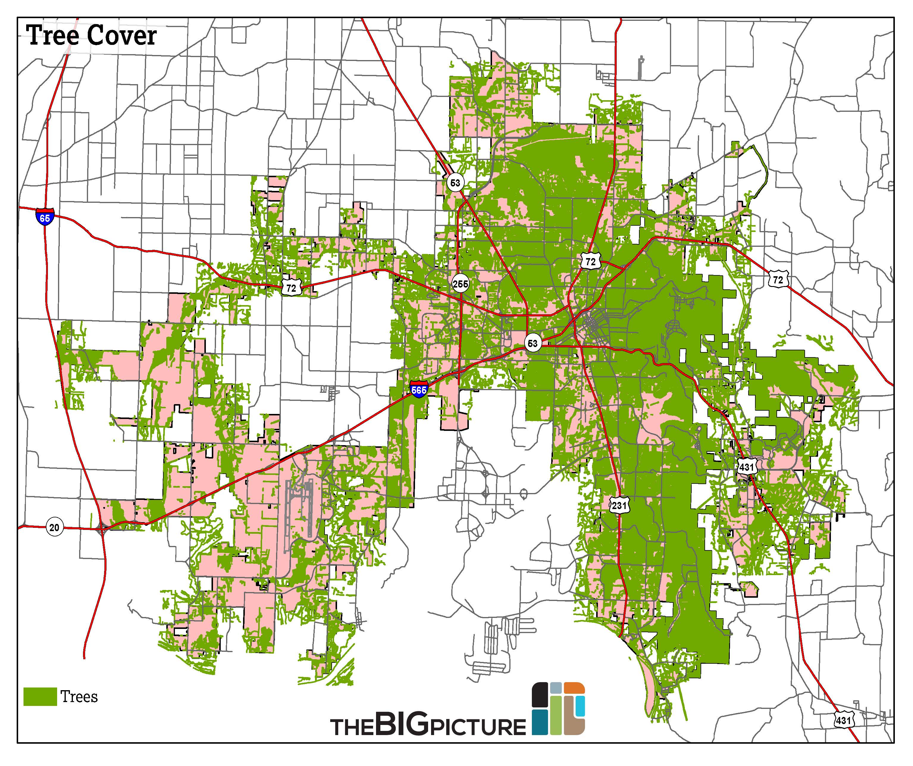
Much of the City of Huntsville is covered in trees, particularly in mature residential areas. Coverage becomes more sparse in industrial and agricultural areas near the Airport, in Limestone County, and in far North Huntsville.
According to the Environmental Protection Agency (EPA), Huntsville is in the transition zone between two ecological regions: the Interior Plateau to the west and Southwestern Appalachians to the east.
Tree cover has been cited by the EPA as a “simple and effective” way to reduce the urban heat island effect.
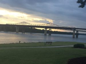
The Whitesburg Bridges, as seen from Ditto Landing.
Ditto Landing is located on the Tennessee River in Southeast Huntsville. The marina includes a campground, pavilion, and greenways. However, there is a sentiment among many in the community that Ditto isn’t living up to its potential, and it could become a regional draw.
The creation of a vision for Ditto and the greater Huntsville riverfront was met with an outpouring of public support at meetings and on our online forum, Imagine Huntsville. The City of Huntsville’s contract with IdeaScale, the platform that brought Imagine Huntsville to life, ended on December 31, 2019. Have an idea for the City of Huntsville? Message the Big Picture on Facebook at Facebook.com/BigPictureHuntsville or an e-mail to BigPicture@HuntsvilleAL.gov. The City of Huntsville, in cooperation with the Huntsville-Madison County Marina and Port Authority (the governing body of Ditto Landing) and the Madison County Commission, set out in 2014 to draw up and implement the Ditto Landing Master Plan. You can read more about the plan and our outreach efforts here.
Many of Huntsville’s historic structures and landmarks—from the Big Spring, where the city was founded in 1805, to the test stands used to test the Saturn V rocket in the 1960s—are on the National Register of Historic Places (NRHP). The majority of structures in Huntsville listed on the NRHP are located in neighborhoods near Downtown, including Old Town, Twickenham, Five Points, and Lowe Mill. Notable exceptions include the Burritt Mansion on Monte Sano, Merrimack Mill Village, and Alabama A&M University, among many others.
Historic Places, Districts, and Markers Map
Type an address in the box below to explore historic sites near you (Madison County only).
Huntsville is fortunate to have a wealth of natural and historic resources, and we have many ways to enjoy them. This includes hiking, biking, and water sports. The City of Huntsville’s Bike Map features many of these outdoor recreation opportunities.
Download North Map Download South Map
Several of Huntsville’s open spaces are ideal for bird– and wildlife-watching.
Huntsville is part of the TAG (Tennessee, Alabama, Georgia) region– an area known internationally for its abundance of caves. The caves in this area are a result of karst limestone geology and the abundance of water. In fact, Huntsville is home to the National Speleological Society headquarters.
Find the perfect space to play in Huntsville’s numerous parks and green spaces, outlined in our Parks and Recreation section in Community Facilities.
Mountains and rivers are considered some of Huntsville’s unique assets. Ensure that any future land use and transportation plans take into account Slope Development Districts, floodplain, and topography.
Identify and preserve potential historic sites and districts.
Work with the Marina and Port Authority to encourage completion of the Ditto Landing Master Plan.
Work with the Land Trust and Alabama State Parks (among others) to continue to preserve our natural wonders and recreation destinations.
Expand the Huntsville recreation “brand” to broaden its exposure as a regional destination for hiking, biking, spelunking, etc.
Last modified: December 31st, 2019 at 10:20 pm